Using satellite data for environmental risk assessment in parametric insurance is a complex activity. Climate change has driven a strong demand for methods to assess flood, fire and wind loss. But it is important to be sure of the provenance of data sources, and you need tools that give you a high degree of confidence and the result. Most of all, you need the knowledge to create risk models that deliver probable maximum loss values that are accurate.
Insurers are seeking a research based solution to improve the speed of data collection, accuracy of analysis, and quality of modelling within the rating process. At Earth Blox, we know that there's an amazing amount of high quality satellite data available for gaining insights. But if you want to use it, the bar is set high. You need coding expertise, fast computers, and you need to be prepared to spend a lot of time on the analysis.
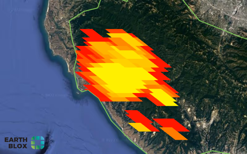
Watch the demo of Earth Blox for assessing fire risk in insurance
We created Earth Blox to be a tool that provides access to the power of Earth observation, removing the need for recording high performance computers, and giving you the power to derive intelligence from satellite data anywhere. With Earth Blox the data and the processing power is held on the Google Earth Engine cloud, which makes it accessible and highly scalable.
The Earth Blox interface has been designed to be simple and intuitive to use. You can upload pre-existing data on the location of assets directly into Earth Blox to extract data and information specific to what you are insuring. You can create your own solutions by dragging and dropping blocks into the workspace to build up complex yet bespoke queries or workflows in just seconds. Each Blox replaces the coding that you would otherwise need to do in order to perform this type of analysis.
For example, we can look at the wildfires that occurred in California during the summer of 2020. We understand that the provenance and independence of the data use is vital for ensuring that you and your customers can trust the outputs. By partnering with Google Earth Engine, Earth Blox provides access to some of the best satellite data available almost immediately. For example, the data on wildfires comes from NASA, and is collected on a daily basis and made available to you within 24 hours of the fire occurring. In addition to building your own analysis, Earth Blox has also been working with industry partners to curate a collection of pre-built workflows designed to answer specific questions or address specific needs.
We can look at 20 years of data to get a long term picture of the risks due to wildfire and cross reference the wildfires with data from the European Space Agency on land cover to gain a more specific understanding of how wildfires are affecting this area. By providing access to data from multiple sources, all in one place, we make it easier for you to get the insights you need.
This workflow will display where the wildfires of 2020 occurred, and how this relates to land cover. It will also show data on which areas have experienced damaging fires over the past 20 years. The dashboard provides you with actionable insights by delivering key data relating to how often a fire has occurred, and how much area has been impacted. This data can be extracted out of Earth Blox and feed directly into your own risk models to estimate metrics such as maximum probable loss. Earth Blox can enable you to get the answers you're looking for in a matter of minutes, cutting the time you were taken to reduce an answer by 95%.
Earth Blox is capable of delivering business benefits to the insurance industry right now. It's here and it works. And what do our customers say? One of our insurance customers shared Earth Blox gives us reliability, and customizability significantly improving our forestry underwriting.
Learn how insurer ForestRe gains competitive advantage using satellite data for insurance in this case study.